
A line shows the course from Point Judith Harbor of Refuge to the entrance to Montauk Harbor.
I've often
been struck by how close the eastern end of Long Island is to Block Island on
the chart. The twenty-six nautical miles
from Point Judith on the mainland to Montauk, LI isn't much more than twice the
distance to Block Island. Gotta do
it. But
when? The summer was busy with teaching
in Upward Bound, church camp and scout camp and family travel for Stephen, school
camp for Trevor, a week-long stay for the whole family at the AMC Ponkapoag
Camp, and then all at once the school year was upon us. Though the trip was planned, and waiting for
the right opportunity, I began to decide that the relaxing week by Ponkapoag
Pond would just have to substitute for a boat trip this year.
But
then the Jewish holidays (traditionally no-school days) fell on
Thursday-Friday, leaving 4 contiguous days to play with--a bit more if we could
get away after school on Wednesday! And
the weather looked promising, if a bit gusty.
I
normally only take Trevor on trips this long; the Beatrice Ann is too crowded with three,
and Trevor is the better sailor of the two boys. But Beatrice couldn't supervise kids with her
work schedule that week, so Stephen went as Second Officer, shoe-horned between
us in the bunks. With some careful
planning we all fit pretty well.
We
rolled out of the driveway on Wednesday just after 6pm--late, as usual. Beatrice came along, so she could take the
car and trailer home rather than chance leaving them 3 nights in a distant
parking lot. We arrived at the Great
Island ramp on Point Judith Pond before 8pm, and pushed off in the darkness
before 9 with Speedbump, our little
plastic kayak, in tow.
The
Pond leads to the open waters of the Atlantic via a breachway hosting tidal
currents of two knots or more--The wind usually foul. I
would not contemplate going against such a current with no motor. The current as favorable at that moment, and
wouldn't be again until 9am next morning.
On the one hand, anchoring overnight in the Pond would give us a quiet
night, but force us to wait until 9am to head for open water. On the other hand, we could go straight out
on the night's favorable tide and anchor safely--if not so comfortably--in
mile-long Point Judith Harbor of Refuge, guarded from most wave action by
artificial stone breakwaters. That done,
we could leave as early in the morning as we liked--important with so many
miles to go, in potentially unfavorable winds.
Decision made: we headed out the breachway in the starry darkness,
dropping anchor safely outside the channel at about 10pm. After shoe-horning ourselves into bed, we
read for an hour, then shut off the lantern and tried to sleep.

Point Judith Harbor of Refuge. You see the problem?
I was
already awake at 3am when I heard the sound of an approaching engine. Alarmed, I popped my head out the hatch to
find a fishing boat bearing down on us.
Almost before I could summon a rational plan, the boat swept past only a
few yards away, leaving me gape-mouthed and rocking in her wake. Although we were not anchored too close to
the channel, nor to the western entrance to the Harbor, the most sensible path
leading to a second, eastern entrance to the harbor. I had been foolish to allow the all-important
lantern to be used for reading, and only dumb luck had kept us alive. I tied the lantern to the cabin top and
turned on both mantles, then returned to
my bunk, ears tuned nervously to the regular sounds of fishermen venturing
forth, keeping me awake most of the night.

Our anchorage in Pt. Judith Harbor-of-Refuge. Above: the breachway.
Below: the distant rock breakwater that makes the harbor possible.

I was up before 7am for a
variation of my usual routine: set water to boil for coffee while I brush my
teeth and wash my face, then ready the boat to sail as the boys got out of
bed. Conservative in the face of
predicted 20kt gusts on blue water, I began by dropping the mainmast, and with
Stephen’s help lashed it alongside and moved the mizzen to the reefing
step. This was the safer of my two
reefing options. the other was to roll
part of each sail around the mast, but this left a baggy mess forward and
limited the boat's effectiveness to sail to weather. Moving the mast instead had the advantage of
preserving the boat's ability to sail to weather, but the disadvantage of
needing to be done at anchor in calm seas.
I knew the predicted winds might not materialize, but wanted to err on
the side of safety.

Interesting traffic. I think this a very practical-looking power cruiser with character.
The barge below was being towed by a tug from a looong way away.


I don't do much blue water sailing, and have always been struck by the immensity of the horizon when I have. This trip I almost didn't notice.

Our course didn't take us very close to our old friend, Block Island.
Besides the light winds and
reduced sail, two other things slowed our progress: first, I handed over the
tiller to Trevor so I could get a nap after an exhausting hour in which winds
were so light as to barely give steerageway.
Winds filled in a bit while I lay down, and when I came back into the
cockpit an hour-and-a-half later I found the boat close to Block Island and far
off course, with the wind abaft the beam but sail sheeted in pretty tight; second
and much later, the mismatch between evident speed through the water and the
much slower gps speed over the ground sent me to Eldredge, there to discover
that we were fighting a current that may have exceeded 2kt in some places.
On the other hand, it was a
really beautiful day, comfortably cool and cloudy, with the most amazing clouds. I took many cloud photos.
I love looking at clouds. Most people hardly ever look up.


On the other other hand, our slow progress meant we neared Montauk Point
in twilight (after a gorgeous sunset), and would have to enter Montauk Harbor
in full darkness. I spent time studying
the chart to fix the positions and patterns of several lights and lighted buoys
in my head, put a headlamp in my pocket, and readied the spotlight in case we
had to get someone’s attention. Clued in
that dinner would be a diy affair, the boys rummaged the aft locker while I
switched on the running lights.
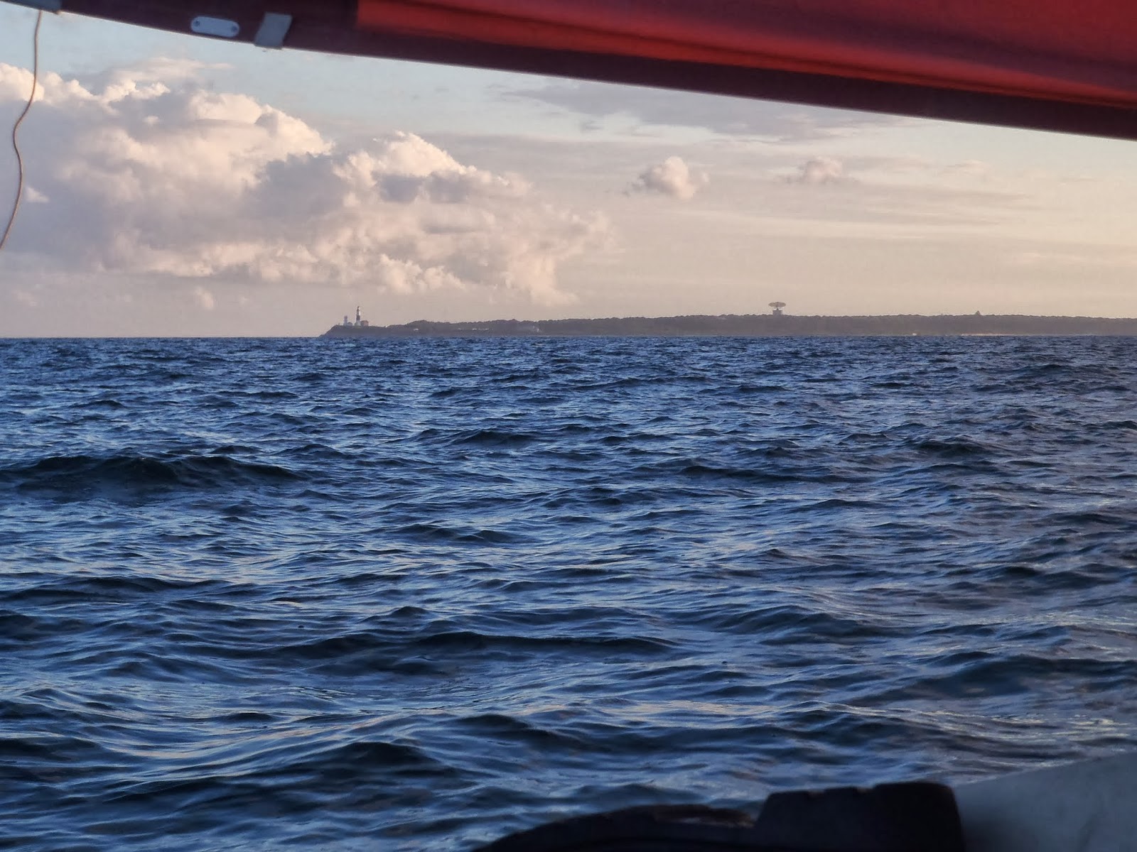
Our first clear look at Montauk Point.
Montauk Light at left, a giant radar antenna right of center.
With the winds fairly light, I had time to do some justice to the sunset.


Lake Montauk was the largest freshwater lake on Long Island until a developer opened it to the sea in the 1920s. Imagine blindly perpetrating such ecological destruction! Times have changed for the better.
After that, things went
smoothly. Returning powerboats showed us
that the water was deep close inshore, and led us to the harbor entrance. The entrance lights were clearly
visible. The moderate current was with
us. Traffic was light. Stephen phoned Beatrice to announce our
arrival as we sailed into the harbor. My
only confusion was finding the narrow passage out of the harbor and into
Montauk Lake proper, amid the visually busy and brightly-lit scene. I finally dropped anchor near the southern
end of the lake, and joined the boys in sleep at perhaps 11pm.
The
next morning was a late one after repeatedly being awakened in the night by powerboat
wakes, and no one stirred much before 8am.
We ate a leisurely breakfast, and then got the anchor up and began
sailing the lake shore looking for a place where we could go ashore and get to
a road without going through someone's yard.
(This is ever the quest of the cheapskate small boat traveler.) Giving up on the south end of the lake, which
had seemed promising on a map, we headed for Star Island and its convenient
causeway. Oddly enough, the south side
of the causeway was totally empty of boats, even though the north side was
chock-a-block. We soon learned why: a
row of floating markers forbade anchoring (among other crimes) anywhere inside
their limits.

We did find one landing place with access to a road, but it turned out to be in the boonies.

After
a tour of the harbor, and a fruitless attempt to contact the harbormaster for
advice, we found a public boat ramp at the top of the lake. A local fisherman there advised that we
probably wouldn't be bothered if we anchored just off the ramp. In the end, we got ashore without unlimbering
the inflatable boat: a minor coup, since repacking the thing tightly enough to fit
in its place under the starboard berth has always been a challenge.

We accidentally shared the public landing with a crew taking photographs for (I suppose) some ad campaign. They posed the model like he was a mannequin. If the car needed to be moved, a driver did it. I overheard one say it was time to get back to NYC. He even said, "Ciao."

Here
is where my uneven trip preparation told: I had prepared well for the passage
itself, but--owing to the last-minute decision to go--had not finished laying
the groundwork for our stay in East Hampton, of which Montauk is one village. I'd had an idea we would hike nature trails, and
maybe visit Montauk Light, but we didn't even have a street map when we
arrived. When we had changed into our
dry shoes, we began trooping south in my mistaken belief that any kind of
"downtown" lay that way.
Instead
of becoming Main Street, our road instead became more and more of a
highway--without even a sidewalk. We
trooped for miles as cars whizzed past.
We gradually developed the idea that East Hamptonites were always in a
hurry (probably to make enough money to keep their big yachts afloat), and too
frenetic ever to walk anywhere. The boys
followed their foolish dad nearly five fruitless miles before we found
ourselves back at the ramp in the fading afternoon. Our time ashore was fast approaching its end.

First Trevor, then Stephen, gets a turn in the kayak.
The Beatrice Ann is below, upper right.

While the boys played with the kayak, I decided to go north toward the harbor entrance, and stumbled upon the tourist life of the harbor: restaurants, a modest food market, and the fishermen, yachtsmen and tourists the town caters to. The three of us returned north in the early evening, watched the sun set over Gardiner's Island, walked the rock breakwaters that protected the harbor entrance, bought ice for the cooler, and then--when cheaper fare was unavailable--went to the Hideaway for a meal of Mexican food. It wasn't the stay I'd intended, but it would do.

Looking east at the harbor entrance, then west down Long Island.


This restaurant looked like a nice place to sit and watch the water traffic
--until I saw the menu prices.

Though I gave them only a few minutes, the boys determine to run to the end of the west breakwater.
In only a few moments, they are on their way back.

A Wharram Polynesian catamaran is an odd sight around here.
Sunset over Gardner Island, Long Island


This is how the crew of the Beatrice Ann spends their evenings.
(I have my book too, and a glass of wine as well.)
Thoreau
said, "only that day dawns to which we are awake." Taking his words to heart, I rose shortly
before dawn to see the sun rise as I sipped my coffee. Then I got the boys up and they helped me return
masts to their places: I decided we would begin under full sail. Strong and gusty winds were again predicted,
but with this difference: with the wind abaft the beam the whole way, I would
not need to worry about windward performance if I reefed by rolling the sails
around the masts.

"Only that day dawns to which we are awake." -H.D.Thoreau
And I am watching that day dawn, coffee cup in hand.
We got
the anchor up just after 7am, and headed for the harbor mouth. Winds were moderate and I felt confident
enough to make instant oatmeal for breakfast with the hot water I'd reserved in a
thermos. The boys had just finished
their second helpings when we began passing out the breakwaters. Two things happened within a minute of each
other: the wind, earlier baffled by buildings, increased to full strength; then
as we left the breakwater behind the boat was rocked by big, steep seas sending
us scrambling for balance.

Montauk Harbor hosts a Coast Guard Station with a armed cutter.

Headed for the harbor mouth.

Stephen has the con while I mix the oatmeal.

I was surprised to see the shore lined with RVs.
I don't know how they got there, nor how far they are above the high tide mark.


Stephen: timoneer.

A closer look at the radar dish.

Trevor, more comfortable with the tiller, got a long turn as helmsman.
Within
a few seconds I had the boat under control and headed downwind along the
coast. Once we had passed Montauk Point
seas moderated, and the boys began taking their turns steering. It seems the steep seas were the result of
currents opposing the strong winds.
These currents diminished when we had cleared the Point.
Now
began the long sleigh-ride home. We got
used to creaming along on wave tops--a few times surfing the same wave long
enough to get the gps up to 10kt: a record.
Since we sailed with the wind, it was easy to forget what the true wind
speed was. But the little yellow kayak
got loose not once but twice, the second time without being noticed right away,
sending us tacking back to retrieve it.
Beating against the strong wind and waves brought home the true conditions.
Report from the half-way point.
As we
got farther from land, I decided we had better reef for safety. We hove to, and the boys kept the mainsheet
running free while I went on the foredeck to rotate the mainmast and wrap up
20% of the sail area. Having forgotten to rig the new mast for reefing, I had
to jury-rig it a bit, but after one abortive attempt, the reef held. I did not reef the mizzen, which would have
to have been done while lying ahull.
With the main reduced a little, the motion became a little less
"edgy," a little safer. (I
told Stephen that if I didn't name our next boat "42," then perhaps
it would be called "Edge of Disaster," since that is the way we
sometimes seem to sail.) [Forty-two is, of course, the
Answer to the Question of Life, the Universe, and Everything, according to
Douglas Adams' Hitchhikers' Guide to the Galaxy.]
The
only other adventure to befall us on the 8-hour ride across Block Island Sound
was the capsizing of the little kayak--twice.
This apparently resulted from our attempts to get the little boat to tow
more easily, rather than alternately dancing in semicircles, bringing up with a
jerk as the slack came out of the towline, and surfing down waves to ram the
bigger boat. Riding on a shortened tow
line, the little boat would sometimes flip over, rapidly filling with water
until all but the aft end was sunk. In
such a position, the kayak was nearly impossible to rescue: too low in the
water to bail out, and too heavy to lift.
After taking a half hour of strenuous to rescue the first time, I got
smarter; the next time it flipped I acted much more quickly so the boat
wouldn't have time to fill. All three of
us would manhandle the loggy thing across the cockpit and carefully dump out
enough water so that the bailer could do the rest. After two such rescues, I entertained the
idea of simply cutting the tow if it happened again. (Coming through the gap in the breakwater
into the Harbor of Refuge, I actually had Trevor standing by with a sharp
knife, since I wasn't willing to risk the big boat near these rocks if the
kayak should suddenly become a sea anchor.)

One mile to Point Judith.
The Harbor of Refuge is over a mile long.
We
came into the Harbor of Refuge at about 3pm--well ahead of the turning of the
tide that would allow us to sail into Point Judith Pond. We dropped anchor at the south end of the
Harbor (where we should have spent that first night), and I enjoyed an hour and
a half of bird-watching. Flocks of birds
that may have been storm petrels flew and floated over the nearby harbor the
whole of this time. I was fascinated by
their beauty, and the nonchalant way they had of landing: floating down the
wind and reaching the water, they simply began floating on the water without
apparent transition.

Bird- an sky-watching in the Harbor of Refuge.

About
4:30pm we headed up the breachway with the early flood tide. I phoned Beatrice to tell her we were
entering the Pond, and she prepared to make the trip down with the
trailer. Since the water in most of Point
Judith Pond is thin to nonexistent even at high tide, we stuck religiously to
the channel until it was time for the turn at the north end of Great
Island. With careful study of the chart
and a sharp lookout forward, we managed not to touch bottom until we were on
our way up the western side of the island.
Then we faced a problem: the wind was ahead of us, and so were depths that
seldom exceeded three feet at low tide.
To make matters worse, the muddy bottom was choked with a dense mat of
algae that fouled the centerboard even before we touched. The wind was still significant, resisting all
other options: neither trolling motor nor oars were equal to it. We would anchor repeatedly to try different
things, then lift the extravagantly-slimed anchor and see if the rising tide
would allow any further progress. Hours
of struggle to go only about a half mile.
We finally arrived at the ramp to find patient Beatrice with the trailer
and some fresh clamcakes and chowder.
She waved away my apologies, saying, "of course you're late: it's a
BOAT."
This trip put a fitting and memorable end to the sailing season, nearly equal to last year's August trip around Cape Cod
No comments:
Post a Comment